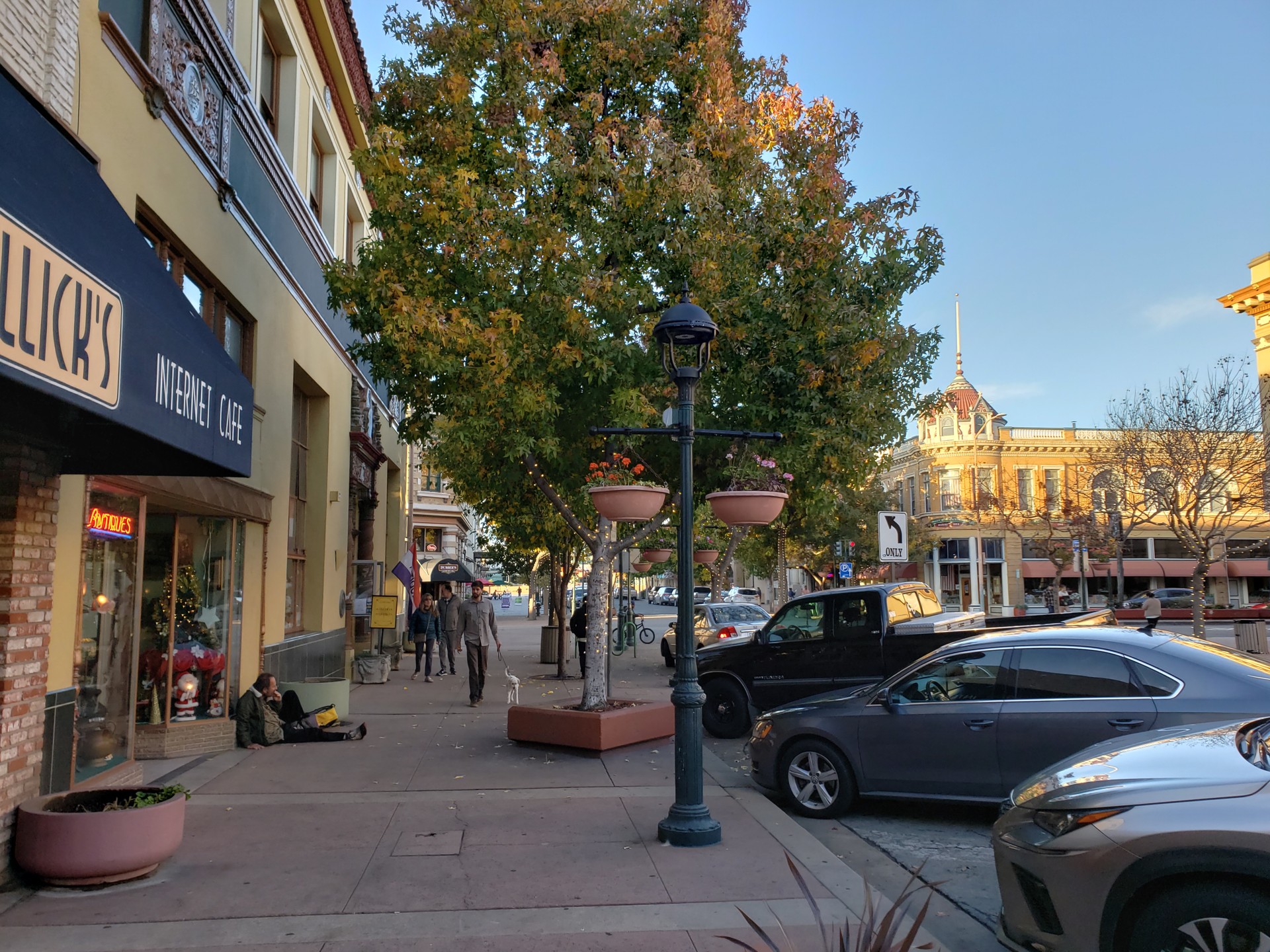
Main Street in Salinas, photographed in 2018

Outdoors

Biking and mountain biking near Salinas

Trails and recreation areas near Salinas open to biking and mountain biking.

27places to ride
14 mito the closest
3within 30 miles
Year-roundbest months

Good to know: Wilderness areas are closed to bikes; check each area’s trail rules and yield to hikers and horses.

Closest picks

1

Monterey Bay National Marine Sanctuary

14 mi west · National Oceanic and Atmospheric Administration

Monterey Bay National Marine Sanctuary is one of the most spectacular marine protected areas. This sanctuary also has one of the largest underwater canyons and closest-to-shore deep ocean environments.
2

White Oaks Campground

25 mi south · USDA Forest Service

Amid a grove of towering trees, eight campsites create a loop within White Oaks Campground, just off Tassajara Road.

3

China Camp Campground

27 mi south · USDA Forest Service

Pleasantly nestled under a large canopy of pine trees, China Camp is a campground where peace and quiet is commonplace. The spacious campsites allow you to set up camp with more than enough space between you and your neighbors.

Map of all 27 places

Map of 27 places loads as you scroll.

Within 30 miles (3)

14 mi west · National Oceanic and Atmospheric Administration

Monterey Bay National Marine Sanctuary

Monterey Bay National Marine Sanctuary is one of the most spectacular marine protected areas. This sanctuary also has one of the largest underwater canyons and closest-to-shore deep ocean environments.

  • Biking
  • Boating
  • Camping
  • Diving
  • Fishing
  • Hiking
  • Horseback riding
  • Paddling

25 mi south · USDA Forest Service · Campground

White Oaks Campground

Amid a grove of towering trees, eight campsites create a loop within White Oaks Campground, just off Tassajara Road.

  • Biking
  • Camping
  • Hiking
  • Wildlife viewing

27 mi south · USDA Forest Service · Campground

China Camp Campground

Pleasantly nestled under a large canopy of pine trees, China Camp is a campground where peace and quiet is commonplace. The spacious campsites allow you to set up camp with more than enough space between you and your neighbors.

  • Biking
  • Camping
  • Hiking
  • Wildlife viewing

30 to 75 miles (16)

32 mi south · USDA Forest Service · Campground

Arroyo Seco

Arroyo Seco Campground is a semi-rustic, but developed facility in California's westernmost national forest.

  • Biking
  • Camping
  • Fishing
  • Hiking
  • Wildlife viewing

36 mi northeast · Bureau of Reclamation

San Luis Lake and State Wildlife Area

Recreation facilities at San Luis Lake were constructed under a cost-share agreement between the Bureau of Reclamation and the State of Colorado during the late 1980s and early 1990s.

  • Biking
  • Boating
  • Camping
  • Fishing
  • Hiking
  • Hunting
  • Picnicking
  • Water sports

38 mi south · USDA Forest Service · Campground

Escondido Campground

Escondido Campground is one of the best kept secrets in the Santa Lucia Mountains. This family-friendly campground boasts scenic vistas that will take your breath away.

  • Biking
  • Camping
  • Hiking

40 mi south · USDA Forest Service · Campground

Memorial Campground

Escape the hustle and bustle of the city at Memorial Park -- a scenic and remote campground tucked away in the Santa Lucia Mountains.

  • Biking
  • Camping
  • Hiking
  • Wildlife viewing

42 mi northeast · Bureau of Reclamation

O'Neill Forebay

O'Neill Dam and Forebay are joint Federal-State facilities located on San Luis Creek 2.5 miles downstream from San Luis Dam. O'Neill Forebay Dam is a feature of the Central Valley Project - San Joaquin Division - San Luis Unit .

  • Biking
  • Boating
  • Camping
  • Fishing
  • Hiking
  • Hunting
  • Picnicking
  • Recreational Vehicles

44 mi east · Bureau of Land Management

Panoche Hills

  • Biking
  • Camping
  • Hiking
  • Hunting
  • Photography
  • Wildlife viewing

46 mi east · Bureau of Land Management

Griswold Hills

Within the steep and rugged Griswold Canyon, BLM land straddles both sides of the road.

  • Biking
  • Camping
  • Hiking
  • Horseback riding
  • Hunting
  • Photography
  • Wildlife viewing

48 mi south · USDA Forest Service · Campground

Kirk Creek Campground

Kirk Creek Campground is an oceanside paradise, with each site overlooking the Pacific Ocean. It offers a variety of opportunities for relaxation and recreation.

  • Biking
  • Boating
  • Camping
  • Fishing
  • Hiking
  • Hunting
  • Water sports
  • Wildlife viewing

49 mi south · USDA Forest Service · Campground

Ponderosa Campground

Ponderosa Campground offers visitors a beautiful location to relax and enjoy nature. It runs along the Nacimiento River, which provides a variety of recreational opportunities.

  • Biking
  • Camping
  • Fishing
  • Hiking
  • History
  • Hunting
  • Swimming
  • Wildlife viewing

51 mi southeast · Bureau of Land Management

Laguna Mountain

The Laguna Mountain Area consists of somewhat rugged terrain with rolling hills covered in dense brush. The area's vegetation is characterized by classic chapparal habitat, oak forests, and grassy meadows.

  • Biking
  • Camping
  • Hiking
  • Horseback riding
  • Hunting
  • Photography
  • Wildlife viewing

54 mi south · USDA Forest Service · Campground

Plaskett Creek Campground

Plaskett Creek Campground offers a beautiful location just minutes from Sand Dollar Beach, one of the largest and most popular beaches in central California.

  • Biking
  • Camping
  • Fishing
  • Hiking
  • Hunting
  • Wildlife viewing

56 mi east · Bureau of Land Management

Tumey Hills

Look closely at the ground you will find evidence of the vast inland sea that once covered the Tumey Hills. The light porous rocks are composed of diatoms, the tiny, bleached, shell-like skeletons of sea algae.

  • Biking
  • Camping
  • Hiking
  • Horseback riding
  • Photography
  • Wildlife viewing

60 mi southeast · Bureau of Land Management

Condon Peak

Located on the outskirts of the Clear Creek Management Area (CCMA), Condon Peak offers rolling grass-covered slopes with a few tall pines and shrubs, as well as steep slopes and rocky outcrops covered with pine and brush.

  • Biking
  • Camping
  • Hiking
  • Horseback riding
  • Photography
  • Wildlife viewing

60 mi southeast · Bureau of Land Management

Williams Hill

Located in southern Monterey County, and standing over 2,700 feet in elevation, Williams Hill offers great views of the surrounding Salinas Valley.

  • Biking
  • Camping
  • Hiking
  • Horseback riding
  • Off-highway vehicles
  • Photography
  • Wildlife viewing

63 mi north · Fish and Wildlife Service

Don Edwards San Francisco Bay National Wildlife Refuge

Don Edwards San Francisco Bay National Wildlife Refuge is located in a vast cultural and natural landscape.

  • Biking
  • Birding
  • Boating
  • Fishing
  • Hunting
  • Nature education
  • Photography
  • Ranger programs

71 mi southeast · Bureau of Land Management

Coalinga Mineral Springs

The Coalinga Mineral Springs National Recreation Trail was designated under the National Recreation Trails System Act in 1981. The trail is located on the scenic southern tip of the Diablo Mountains.

  • Biking
  • Camping
  • Hiking
  • Horseback riding
  • Hunting
  • Photography
  • Wildlife viewing

75 miles and farther (8)

76 mi southeast · Bureau of Land Management

Stockdale Mountain

Private property surrounds Stockdale Mountain. Do not enter through private gates or fences.

  • Biking
  • Camping
  • Hiking
  • Horseback riding
  • Hunting
  • Photography
  • Wildlife viewing

79 mi southeast · Bureau of Land Management

Curry Mountain

Parking access onto nearly 1,800 acres of Bureau of Land Management property in this area is provided through an easement from the California Department of Fish and Game.

  • Biking
  • Camping
  • Hiking
  • Horseback riding
  • Hunting
  • Photography
  • Wildlife viewing

89 mi northwest · National Park Service · Campground

Aquatic Park Cove, Black Point Overnight Anchoring, Sailing Vessels only (auxiliary engine OK)

Aquatic Park Cove is a vibrantly urban harbor that mimics a natural anchorage and is located on the Pacific shores of one of America's great West Coast cities.

  • Biking
  • Boating
  • Camping
  • Climbing
  • Fishing
  • Hiking
  • History
  • Horseback riding

90 mi northwest · Presidio Trust · Campground

Rob Hill Group Campground

As San Francisco's only group campground, Rob Hill offers a national park camping experience just minutes from the city.

  • Biking
  • Birding
  • Camping
  • Hiking
  • History

92 mi northwest · National Park Service · Campground

Kirby Cove Campground

Kirby Cove is located just north of the Golden Gate Bridge at historic Battery Kirby. Visitors are awarded breathtaking views of San Francisco, its famous Golden Gate Bridge, and the rugged Pacific Coast of northern California.

  • Birding
  • Camping
  • Fishing
  • Hiking
  • History
  • Mountain Biking
  • Picnicking
  • Water Access

93 mi northwest · National Park Service · Campground

Bicentennial Campground

Bicentennial Campground is in an ideal location in the Marin Headlands surrounded by a grove of cypress trees. The campground is a great location for those wanting to camp near the city.

  • Biking
  • Camping
  • History
  • Mountain Biking

95 mi northwest · National Park Service · Campground

Haypress Campground

Haypress Campground is nestled within the coastal scrub of Tennessee Valley, near Mill Valley. The hike to this campground is 1 mile from the Tennessee Valley Trail head parking lot, which means car or RV camping is not allowed.

  • Biking
  • Birding
  • Camping
  • Hiking
  • Wildlife viewing

100 mi southeast · USDA Forest Service · Campground

Cerro Alto Campground

Cerro Alto Campground is a well-known hiking and mountain biking paradise. It is located a short distance from the sandy beaches of Morro Bay, where visitors enjoy surfing, fishing, kayaking, sailing, scuba diving and more.

  • Biking
  • Boating
  • Camping
  • Fishing
  • Hiking
  • Hunting
  • Swimming
  • Water sports

Distances are straight-line miles from downtown Salinas. Listings come from Recreation.gov’s federal recreation database; check each official page for hours, fees, fire restrictions and closures before you go.

Get outside around Salinas

Places to see in Salinas part two! video thumbnail

THINGS TO DO · YOUTUBE SHORT

Places to see in Salinas part two!

An activity Short shared by Lis.

Watch on YouTube ↗
Top 10 Best Tourist Places to Visit in Salinas, California | USA - English video thumbnail

THINGS TO DO · YOUTUBE SHORT

Top 10 Best Tourist Places to Visit in Salinas, California | USA - English

An activity Short shared by Wiki Peaks - Shorts.

Watch on YouTube ↗

Around Salinas

Main Street Salinas Midblock
Main Street Salinas MidblockAgarre16 · CC BY-SA 4.0
Fullsizeoutput 66b, Salinas
Fullsizeoutput 66bPeter Robbert · CC BY-SA 4.0
Main Street, Salinas
Main Street, Salinas (cropped)Naotake Murayama · CC BY 2.0

More outdoors near Salinas

Questions

Where is the closest place for biking near Salinas?

Monterey Bay National Marine Sanctuary (National Oceanic and Atmospheric Administration), about 14 miles west of Salinas as the crow flies. Next are White Oaks Campground (25 mi) and China Camp Campground (27 mi).

When is the best time for biking near Salinas?

Based on Salinas’s average highs, all year. Conditions at higher elevations can be much cooler.

Who manages these places?

Federal agencies including USDA Forest Service, Bureau of Land Management, National Park Service. Each listing links to its official page for hours, fees, closures and current conditions.

Salinas AI

Your Salinas local guide
Hey there!

I'm Salinas AI. Ask about local food, shopping, history or a day out.

AI recommendations may be inaccurate. Verify hours and prices. Questions are processed by Cloudflare. Privacy